OLD CAMP JEFFERS
BY DON DOUCETTE
There once was a connected footpath along the western side of the Bungay River wetland between Attleboro and North Attleboro – all prior to modern housing development.
There was in fact a Boy Scout camp in North Attleboro close to the Bungay River called Camp Jeffers. Today, all houses and streets, was a slopping little blue stem grass meadow approach from Kelly Blvd. behind the small, closed gas station – was originally Forget’s repair garage.
The National Fish Hatchery was developed during my childhood years and the tall Bungay Lake diving board (Greenwood Lake) was still in use circa. that time.
An elder friend, the late Ken Dyer of Attleboro, once storied me that when he was a young Boy Scout his Attleboro troop hiked those old Bungay River trails while carrying rolled blankets so to happily camp and recreate on the grounds of old Camp Jeffers.
All gone today but for our oral tradition story times and coupled with fleeting old, aged memories.
Who among our dear readers can add to this account?
Don Doucette
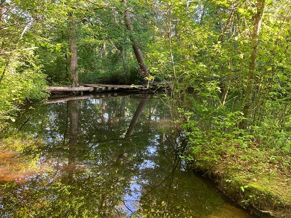
Here is a text and recent photo of the Bungay River in the old Camp Jeffers vicinity in North Attleboro taken by Ben Cote.
It is my personal opinion that we determine the actual remaining footprint of the old camp and devote special attention yearly as a sensitive historic and green open space within the Ten Mile River Watershed.
Don Doucette
We have a real jewel behind North Purchase Cemetery. The Bungay River- wild and scenic and completely out of place here in southern New England.
This looks like an old swimming hole.
I’m told the trail here used to be a Boy Scout camp and that it eventually goes to Lindsey Street.
Lots of beaver activity- a pond, dam and lodge on the way in. I The Bungay River will be celebrated. It’s due.
Ben.
AND SOME ANSWERS
Hi Don,
I remember Ken Dyer. Back in the 1950’s all the Attleboro Boy Scout troops had designated camp sites at Camp Jeffers. I recall Troop 7 (Bud White – Scoutmaster), which I believe was affiliated with St. John’s Church, had a cabin on their site which later burned down.
There was a makeshift bridge crossing the Bungay River from the dirt access road that ran into the site from Kelly Blvd. It was at a flowing impoundment creating a natural swimming hole for us that we would always take advantage of in the hot summer weather.
Part of the Camp Jeffers Boy Scout experience was leading fellow scouters through the Bungay River woods from the West side Holden Street bridge to Camp Jeffers and back to meet their 5-mile 2nd Class Rank hiking requirement.
There was no trail, so we’d follow the watershed’s natural eskers using a compass for the 2 1/2-mile woodland portion of the hike. There were landmarks like the Turkey Farm near North Purchase Cemetery and the Angle Tree Stone Rod & Gun Club properties, which at that time extended deeply into the watershed, that told us how far we had traveled.
I clipped a couple of current aerial view maps to show the general area where Camp Jeffers was located which, to the best of my recollection, was the area on the East bank side of the labeled Bungay River on the map and between the dirt clearing.
I’ve always had an urge to try and access the former Camp Jeffers site to see what the area looks like today. Camp Jeffers provided kids like us with the opportunity to experience local overnight camping which was about as primitive as you could get in Attleboro.
Also, using this wonderful technology available to document the site with information I never knew would be great, e.g., how much property did the camp encompass and the exact Troop camp site sizes and assignments. There must be a map showing the sites somewhere in the Annawon Council archives or county deed records.
JOHN BUCHANAN
Not a problem for me.
Sadly no photos from me as I would have likely plopped my “Brownie” in the river anyway.
Further thoughts about the old days made me think about my more sophisticated trips back with our bicycles and fishing poles. Sleeping bag lashed to the handlebars, an overflowing knapsack and a few canned goods pilfered from the kitchen pantry.
Fun but seemly unreal to consider for young people today if they even wanted to be outdoors.
PHILIP BOUCHER
Hi Don,
You might want to talk to Brad Pitman. He told me about a relative of his that had a nature preserve in that area too. May have been the same property. His relative was some well-known nature writer or something along those lines.
I know that there used to be some small log cabins on property along Kelly Blvd. that weren’t visible until they started clearing the property for development.
Bob Lanpher
Geocache Description:
The cache is on land owned by the N. Attleboro Fish Hatchery. Access it by parking at the Hatchery on Bungay Road. The parking lot is only open during Hatchery Hours. Limited parking is always available on the small section of road before the gate across the street from the Hatchery. The gate prevents motor vehicle traffic, you may enter on foot, follow the road/trail around to find the cache. ALL FORMS OF FISHING AND HUNTING ARE STRICTLY PROHIBITED! Please report any violations to the Hatchery.
THE HATCHERY GATE IS LOCKED AT CLOSING TIME! Hours of operation are posted on the gate. This cache is placed on land owned by the North Attleboro Fish Hatchery and a part of the Bungay River Watershed.
Back in the 1950’s the area on the other side of the river near this cache was owned by the Boy Scouts of America and known as Camp Jeffers. Little evidence of Camp Jeffers remains today.
There are some remnants of tents and tent poles, as well as a few odd clearings and other relics.
I believe the camp was disbanded when the Bungay River watershed was established as a protected area. Which was also a factor in why I-295 ends so abruptly (See GC36725)
There might be other reasons for the camp’s demise; information on Camp Jeffers is scarce. If you wish to visit the actual area of the camp, proceed South from the cache, following the trail, along the edge of a field, then bare left when you re-enter the woods.
Cross the small wooden bridge AT YOUR OWN RISK, also be aware there are many unmarked trails on the other side.
ANNAWON COUNCIL MINUTES
1931 there was talk about purchasing a camp site off Little Island Pond in Plymouth.
During 1932 first serious consideration was given a Council-owned camp site for Annawon Scouts. Although considerable thought was given to a site on Lake Mashpee on Cape Cod, the Council reneged on a thirty-day option to buy the property.
During the summer of 1932 the invitation of Old Colony Council to camp with them at Camp Childs on Morey’s Pond was accepted.
On October 1, 1932, as a result of the permission of Mr. Clement Jeffers of Attleboro, a camp site for weekend camping was dedicated as Camp Jeffers.
In January of that year, Dr. Joseph L. Murphy was again elected president.