ACCUWEATHER
Post-Thanksgiving travel: Wintry weather to coat roads in New England; Rain to drench Plains
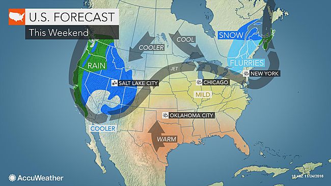
AccuWeather Global??Weather Center – November 25, 2016????-??AccuWeather reports??post-Thanksgiving travel will be hindered by wind, rain and snow across parts of the United States on Sunday.

While Pacific moisture continues to inundate the West Coast, a storm will develop as it moves out of the Rockies and snow showers continue to sit over the Northeast.
Snow showers, freezing temperatures to linger in the Northeast
The system that made for a dreary Thanksgiving in the Northeast will make its way out of the area later this weekend as holiday travelers return home.
“A departing storm system may bring some light snow showers and below-freezing temperatures to parts of New England into Sunday morning,” AccuWeather Meteorologist Kyle Brown said.
Although little snow is expected to accumulate on roadways, temperatures in parts of northern New England and New York state will not rise above freezing.
“This combination could lead to some slick spots on untreated roadways,” Brown said.
No precipitation is expected along the Interstate 95 corridor, and temperatures are not expected to drop near freezing until the overnight hours. However, rainfall from earlier in the weekend may still freeze on paved surfaces after sunset.
Drivers should be vigilant for areas of black ice and drive with caution, particularly on bridges and overpasses as well as over higher elevations.
Late-day rain to drench central Plains
After a dry Sunday morning, a storm forming over the center of the country will spark areas of rain over much of Iowa, Nebraska, Kansas and Missouri.
“Travel conditions early Sunday should not be much of a problem in the Plains, but travel delays will likely increase by the end of the day,” Brown said.
This afternoon rain may will include some heavy thunderstorms, bringing the threat for localized flash flooding on this busy travel day.
Interstate 80 in eastern Nebraska and Iowa as well as Iowa’s Interstates 29 and 35 are expected to be in the bullseye of the heaviest late afternoon and evening rain.
Particularly at highway speeds, hydroplaning is be possible on newly wet roadways. Drivers should avoid flooded roadways and drive cautiously in areas of heavy rain that may lower visibility.
Increasing winds throughout the day, as well as locally gusty winds in thunderstorms, will pose a threat to travel on the ground and in the air.
“South to southwesterly wind gusts in excess of 40 mph from the Texas Panhandle into western Kansas could delay flights and make interstate travel treacherous at times for high-profile vehicles,” Brown said.
Snow, cold to threaten Rocky Mountain travel
With snow expected from the Cascades to the Four Corners, all forms of travel through the mountainous West will be impacted.
Any travel through the higher terrain will require careful driving and acute awareness of the elements when it comes to both snow and wind. Slick roads, low visibility and sub-freezing temperatures will all contribute to the adverse conditions.
“Snow will fall across the central Rockies, where 2-6 inches will be widespread in Wyoming and Colorado, while higher elevations could get closer to a foot of snow,” Brown said.
Rain is expected to fall in parts of Southern California and the Desert Southwest, which will pose a threat to holiday travel in usually dry areas.
Dry in the Southeast
While rain is desperately needed, it will evade the southeastern U.S. through the weekend.
High pressure will promote clear skies and light winds, making for smooth driving conditions. The only threat to travelers will be possible areas of reduced visibility due to wildfire smoke.
By Faith Ehert, Meteorologist for??AccuWeather.com
